On 3/19, five hardy souls – Adam, Albert, Jason, Mitch and Thai set out to pre-ride the 3/26 Island Views 300k route. This report is based on their experience as well as an earlier pre-ride by Mark, Mark, and Vinnie.
Parking
There is ample parking at the Safeway about 100 ft north of the Starbucks and at the Park & Ride (.4 miles north).
Do not park at the Starbucks — there isn’t much parking and the signage suggests your car won’t be welcome for long.
The first 100K
After dealing with paperwork at the Ave D Starbucks that’ll serve as our start control, we set out into the morning darkness. The route heads west, and then north on reasonably quiet roads to Mt Vernon. We stopped here for coffee and baked goods at Ristretto Coffee Lounge & Wine Bar but you may want to keep moving to add time in the bank for later. We then proceeded further west and north to State Route 20 before the bridge. On the bridge we recommend taking the separated pedestrian/biking path. Welcome to Fidalgo Island.
Island Views
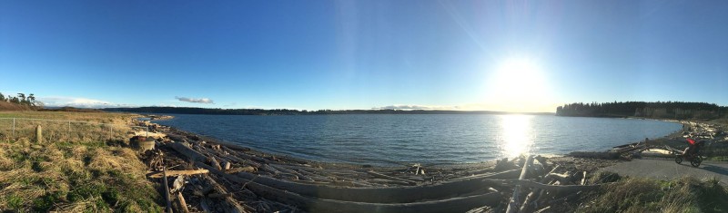
Once on Fidalgo, you’ll quickly leave 20 to explore northwards on quieter roads and trails to March Point. This segment features views of the bay, islands and shipping as well as the oil refinery. After the refinery, you’ll take the Tommy Thompson wooden trestle bridge across the Fidalgo Bay Aquatic Reserve. The bridge (and the subsequent trail) are multi-use and you can expect to encounter a few pedestrians and other bicyclists. The bridge also features shells deposited by local birds. We had one flat on an older tire caused by the shells.
Once across the bridge, you’ll head north to Anacortes and and a control at The Market at Anacortes. The control is open but the market has a good selection of soups, breads, general groceries, and a coffee shop with exterior seating. The pre-riders recommend you fuel up in Anacortes. There is also a bike shop across the street.
From Anacortes we headed further west for more coastal views and hilly terrain before turning south towards Whidbey itself. To get onto Whidbey, you’ll be crossing Deception Pass — take the lane here. There is no control here but it’s worth stopping to take a look. Once across the bridge you are on Whidbey Island.
On Whidbey, we take you South around the naval base and then down to the coast for quieter riding and some hills. There are some services on this stretch while it remains on 20 but with decreasing frequency as you venture further south. At Fort Ebey State Park you’ll find a SIR manned control at a picnic shelter with rando delicacies and a view. You don’t want to rest too long before heading out as more climbing awaits between the park and La Conner.
From the manned control we go west and north around Penn Cove and continuing along the coast collecting views and hills. Again the services are limited until you reach the city of Oak Harbor — the largest city on the Island where all manner of sustenance can be found. From there we head back across Deception Pass and on to La Conner.
The last 80k
In La Conner we enjoyed sandwiches at the Pioneer Market but the control is open if you prefer other fare. The route from here will be familiar to many as you race east towards Lake McMurray, and then south on the Centennial trail. Full services can be found along route 594 and in Arlington (7-11, others). On our pre-ride, we found the Lake McMurray store closed as well as the Arlington public services.
As you arrive in Snohomish, remember to turn on 10th and head over to Ave D. There we will await at Starbucks (til 8pm), then Safeway (indoors or in a van in the lot with the flashing SIR sign).
The route features some 8k+ ft of climbing over 308km You can think of it as a ride of 3 parts — 100 km of relative flat to Anacortes, 100 km on Whidbey/Fidalgo over hilly coastal views, and 100 km of relative flat to get to the finish.
Pre-registration
Help the organizers by pre-registering for this brevet here: