The ride begins and ends in the Renton Village shopping center, 601 S Grady Way, Renton. The start is at the Starbucks. Recommended parking is north across Grady Way at the South Renton Park & Ride. The finish will be at the Applebee’s until it closes at midnight, then at the volunteers’ cars in the parking lot. Fast riders (you know who you are) please text the organizers from Enumclaw so we know when to staff the finish.
This ride will have no on-course support. Carrying adequate water for the climb to Cayuse Pass is essential. Devise a way to carry more water than you normally do.
The forecast is for warm and clear conditions. Be prepared with plenty of sunscreen and perhaps protective clothing.
The descent from Cayuse Pass may be cold, particularly for tired and dehydrated riders. Bring a wind jacket and some warm clothing.
The preride started in early morning sunshine. Clouds soon moved in and conditions remained unexpectedly cool, verging on cold, all the way to Elbe. This was the first time I have been in Eatonville when it was not stinking hot. It’s not all that bad a place.
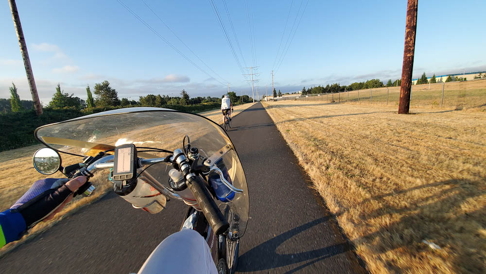
No rabbits in sight – full speed ahead! Four water bottles!
The route begins with a long roll on the Interurban Trail with its numerous railroad crossings. Many of the rubber tiles at the crossings were recently renewed. Not all, however! Most of the crossings are oblique to some degree, so exercise caution at the crossings.
Stay alert for suicide rabbits. The rabbits look well-fed this year. Hitting one could take you down.
If the weather is clear you should get the first views of Mt Rainier, awakening from its overnight slumber, unaware yet of your approach.
After taking surface streets in Pacific the route transitions to the Sumner Link trail with pleasant views of the White River. The trail has some surprisingly sharp turns so heed the warnings in the route file.
In Sumner you ride the aptly named Traffic Ave, then turn onto Shaw Rd. Shaw begins with a bridge that is steeper than it looks. The extra-wide sidewalk is recommended for the climb.
The next long segment is on the Foothills Trail to Orting. A public restroom with water is located close to the start of the trail. Like the Sumner Link, this trail has surprisingly sharp turns, generally when approaching rail crossings. Expect pedestrian and casual bike traffic to increase as you approach Orting, although it may be relatively light due to the early hour riders should reach Orting. Keep in mind the local drivers expect to have their right of way at intersections.
The route does not follow our traditional way through Orting! The aim is to avoid the busy intersections and pedestrian traffic on the trail in central Orting. Be alert for the right turn onto Whitehawk Blvd. A “landmark” instruction at the school track is intended to wake you up. If you need supplies there is a cue to head off-route at Whitsell.
Next we head south past Lake Kapowsin and Ohop Lake to Eatonville. These roads were unexpectedly quiet on the pre-ride, possibly because we were on them several hours earlier than has been the case with routes that start in Seattle. Turning onto WA-161 expect impatient loud traffic on the climb into Eatonville.
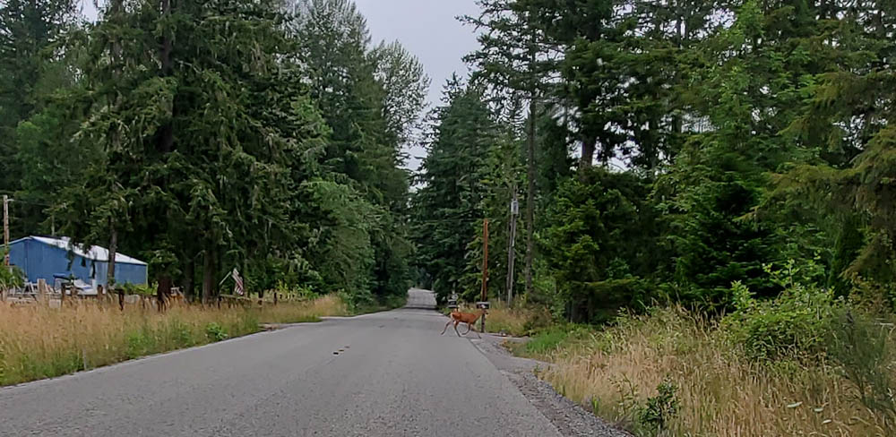
From Eatonville the route follows the less busy option to Alder Lake, highways 161 and 7. Shoulders were good except for a few tight spots. Pretty forest appears. Be alert for deer (and elk) (on the entire route).
Oh deer!
Turning alongside Alder lake on WA-7, Mt Rainier suddenly looms, challenging, “Who approaches?”
“Who enters my domain?”
Running toward Elbe at up to 25 mph we enjoyed a great tailwind. The temperature rose abruptly into the 70s. We walked the evil track crossing just before town.
This crossing is not a peach
In Elbe we found packaged sandwiches (expiration date in August!) at the Elbe Junction, opposite the decaying Heisler logging locomotive. There are several other options for food.
Steel is real
Leaving Elbe we walked the second abominable track crossing. The run to Ashford is generally a false flat. Don’t knock yourself out trying to make speed here. Ashford offers a couple of stores for final supplies before climbing to Skate Creek.
The climb to Skate Creek was well shaded and quiet with good road surfaces. At one point you may feel you are being watched – what, is it Sasquatch? No, the Mountain is surveilling you through the trees. The trees part and the stern, silent Mountain assesses you, then slips back behind the trees. What does the Mountain plan for you?
“You persist, mortal?”
The Skate Creek summit transitions gradually to downhill, and then becomes seriously downhill. The road is in much better condition than I have seen it at times, but hazards still abound. Most potholes have been circled with paint, but not all. The dappled light under the trees demands full attention. Be satisfied with listening to the cascading waterfalls. Don’t look at them! Finally the right-hand hairpin turn heralds arrival in Packwood.
Skate Creek
In Packwood we ate at the convenience store at the intersection with US-12. It is now a 76 gas station. The outdoor portable toilets were out of paper; you might want to bring your own supply. There are other food options in Packwood if you go off-route right on US-12. Leave with a full load of water and food.
Heading east on US-12 the climb to Cayuse Pass begins with ascending rollers. They seem fun despite the lack of shade. The temperature rapidly rose into the 90s. Then the Mountain flicks the grade up to 5% and enlists the sun to torment the unworthy. My gps recorded 102 degrees alongside a basalt wall. When you find the rare spot where a tree’s shadow stretches across the road, stop in it and cool down.
Pass the gantlet, and the Mountain grants reprieve on shady WA-123. As a National Park road, commercial truck traffic is banned and most of the car drivers seemed mellow. After about three miles you pass Ohanapecosh Campground. I had drunk so much water in the ten miles from Packwood that I opted to get more water here. It was a good idea. Notes for finding water here and later at Silver Springs Campground have been added to the RwGPS file’s description. These are not in the cue sheet!
Shade on hwy 123
I cannot overemphasize how important hydration on this climb is, and how necessary to carry a great deal of water particularly if you are slow climber. I drank five bottles on this climb plus most of a bottle of liquid food. Don’t be tempted to pour water over your head. With a limited supply it is much wiser to drink your water.
Eventually the tree cover becomes sparse and you are again exposed to the sun. Fortunately the air becomes cooler at higher altitudes. Unfortunately, the air becomes thinner while the grade increases to 4-6%. If you’ve had as little altitude exposure this year as me, you will notice.
Getting high
The only truly unpleasant part of WA-123 is the tunnel at 190 miles. Be absolutely certain to turn your lights on!
Keep plugging along and eventually the Mountain will acknowledge your spirit, permitting your arrival at Cayuse Pass. Don’t fret if you are behind the clock, you’re about to become a gravity bomb. The upper five miles of 410 descend at 7%. Some braking is needed to hang on to the corners and the road surface is a bit rough in places. Drivers may be afflicted with must pass bicycle syndrome despite you perhaps reaching 45 mph or more. I confess it was gratifying seeing how desperately the drivers braked when they realized how hot they were coming into the next curve.
After an info control at Crystal Mountain Blvd you may want to stop at Silver Springs Campground to fill a bottle. Instructions for finding the water are in the RwGPS description.
In Greenwater only Naches Tavern was open when we arrived. Being Sunday night, and being Naches Tavern, they were out of food. Perhaps they will be better stocked on Saturday. The water we got from the bar was vaguely tainted with cherry soda.
We finished the descent to Enumclaw in the dark. This was not fun. I recommend trying to get to Enumclaw in daylight. Enumclaw has numerous food options. We opted for the traditional randonneur repas en plein air, namely chips and soda on a convenience store sidewalk.
From Enumclaw the route courses north across the plain toward Green Valley. We hit surprising pockets of cold air. After dropping into Green Valley the route hits you with a final steep test heading toward Lake Sawyer.
The last fifteen miles are an easy roll down the Maple Valley trail. In the dark don’t miss the turn to the trail from Maxwell Rd. Maxwell becomes steeper downhill just after, so be mindful here. On the trail be careful of the posts at road crossings. At the Renton end of the trail ride slowly and be respectful of pedestrians.
Renton’s one-way streets send us on the usual indirect wander through downtown. There is extensive road construction. Skinny-tire folks should be wary of pinch flatting.
Comments Off on Summer 300k Brevet Pre-ride Report