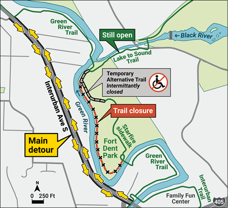
The Green River Trail is closed at Fort Dent through October 2026 as part of the levee reconstruction project. Although a temporary trail has been built around the construction zone, do not use it. The surface is very slow, loose shredded bark, and the trail is not guaranteed to always be open. The detour is to ride on the sidewalk along Interurban Ave S or in the roadway.
King County
At the north, the detour begins at the casino, at S 141st/58th Ave S. Continue on the sidewalk instead of turning east on the GRT.
At the south, the detour begins at Fort Dent Way. Where the GRT and Interurban Trails meet Fort Dent Way, turn left toward Interurban Ave S, then right on the sidewalk along Interurban.
If your route uses the Lake to Sound Trail (formerly Black River Trail), it is still accessible from the GRT. At the casino, follow the GRT.
The following routes are affected. The detour has not been incorporated into the RwGPS files. The detour is about 0.2 km shorter than staying on the GRT; rides that use the detour in both directions will be about 0.4 km short. Ensure that you ride some extra distance if necessary to meet the route’s official distance.
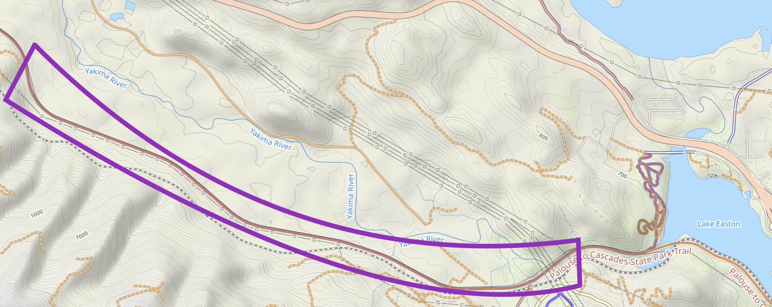
Emergency Closure: The Palouse to Cascades Trail will be closed near Lake Easton between Monahan Rd and Stampede Pass Rd from June 22 to July 13, 2026. During the winter there was a landslide that required this section of the trail to close. This closure is for large equipment to access the site to help with the stream diversion. There is no detour for this section.
During the previous closure cyclists were informally allowed through the work site. There is no guarantee that will happen again. Let’s not slow the work down by trying to cross the work zone.
Many permanents on the trail are affected. Permanents still rideable are:
03653 – Iron Horse Trail
04882 – Snoqualmie Valley, Middle Fork, Snoqualmie Tunnel
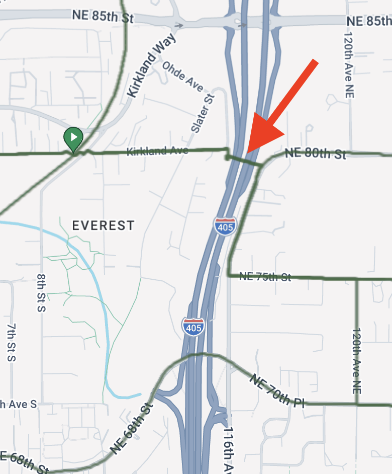
The pedestrian bridge at NE 80th St in Kirkland has been closed indefinitely because of recently discovered damage. Four permanents are affected. Rerouting is fairly easy using NE 85th St or NE 70th Pl–NE 72nd Pl–NE 68th St. NE 85th St is not recommended due to construction.
Thanks to fantastic work by government agencies and independent organizations a bypass trail around the large slide that closed the trail between Rattlesnake Lake and Olallie State Park officially opens on June 5. Additionally the damaged sections at Carter Creek and west of Lake Easton have been repaired. All permanents using the trail will be rideable starting June 5. Several permanents that start at Olallie State Park and Hyak are already rideable. (All pending reactivation by RUSA).
The bypass trail is narrow. Washington State Parks asks that you walk your bike on the bypass.
There are reports of loose gravel in the Whittier Tunnel, aka tunnel 49, west of Lake Easton.
3653 Iron Horse Trail 4180 Wet Side-Dry Side 4882 Snoqualmie Valley, Middle Fork, Snoqualmie Tunnel 5081 Iron Horse & Middle Fork 5115 Three Lakes and a Tunnel 5175 The Real Northern Exposure 5789 The Shortened Real Northern Exposure 5790 Homestead Valley-Easton on the Iron Horse Trail
Thanks to Dave Harper for alerting me to this news.
Comments Off on Palouse to Cascades Trail reopens early
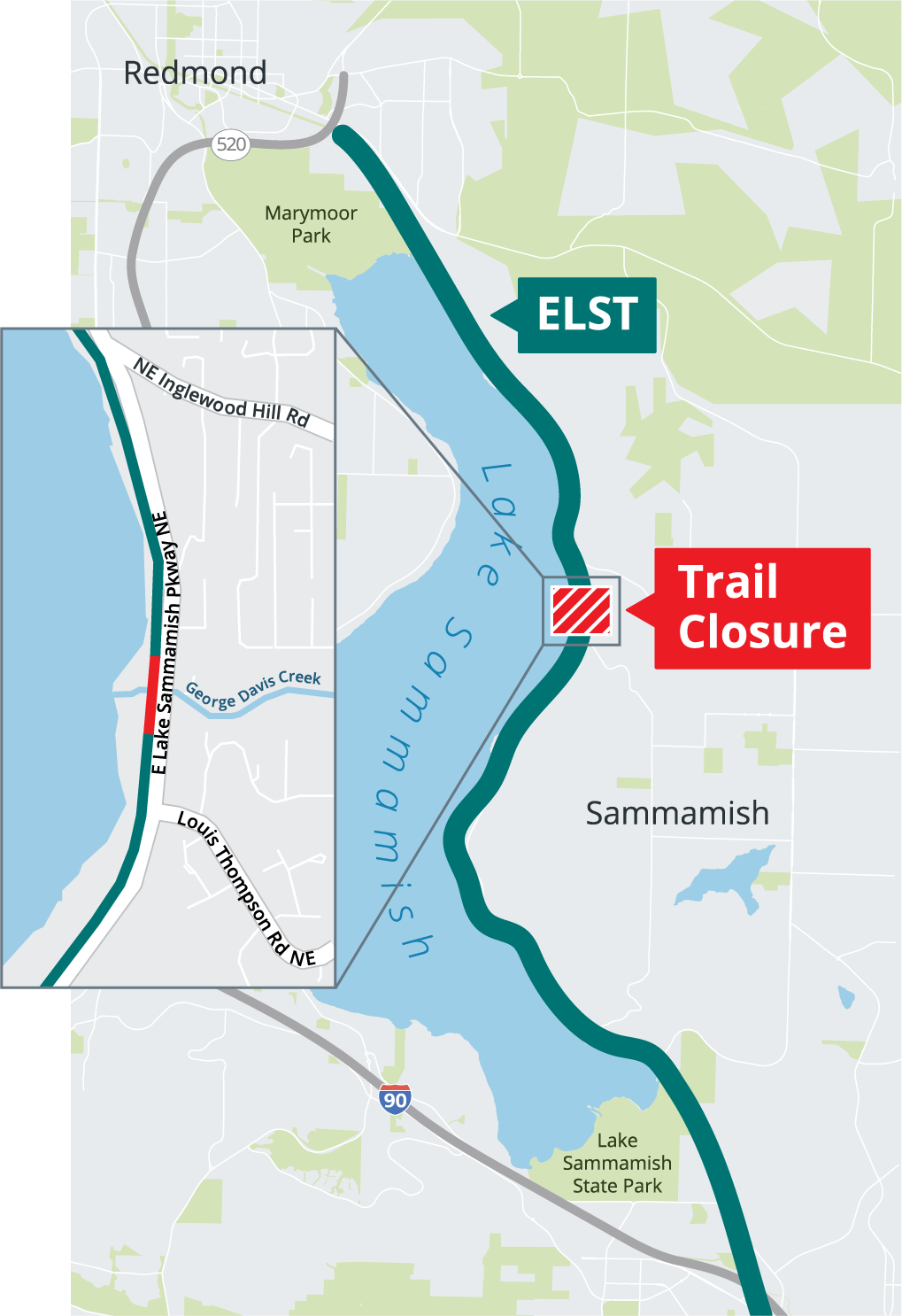
On June 1 King County will close the ELST through the end of the year for the George Davis Creek culvert replacement project. The location is midway between NE Inglewood Hill Rd and Louis Thompson Rd NE.
The trail will be completely severed during construction. Riders will have to detour to the adjacent East Lake Sammammish Parkway, if it too is not closed. A large number of permanent routes are affected.
According to King County, there will not be a bicycle detour. Typically this means no accommodation will be made for bikes on the road, such as a coned-off lane or wayfinding detour signs.
The culvert under East Lake Sammammish Parkway will also be replaced. The status of the Parkway during construction is unclear. Official messaging has been inconsistent. The latest verbal information an SIR member obtained from the City of Sammammish is that the road will remain open. Likely there will be delays at the construction zone.
Presuming the Parkway remains open, riders can detour on the Parkway. We do not know exactly where the north and south ends of the closure will be, so right now cannot recommend where to exit to the Parkway and later return to the trail. Keep in mind property owners adjacent to the trail are jealous of their private roads and driveways.
In the event the Parkway is entirely closed, riders will have to climb and descend Louis Thompson and Inglewood Hill Rds along with detoured car traffic. In this case, routes not using the ELST will be more attractive.
Update 5/2/26: The closure east of Hyak is still in place.
Update 5/1/26: The closure east of Hyak has been lifted.
For us on the west side of the Cascades, riding season on the Palouse to Casades Trail traditionally starts with the Snoqualmie Tunnel opening on May 1. But randonneuring season the trail will be delayed this year. The P2C trail suffered impassable damage in several places during the ’25-’26 winter. Initially the outlook was dismal; significant repairs were not expected to be possible this year. Fortunately major work is underway. The full trail should be rideable later in summer.
Rattlesnake Lake to Snoqualmie Tunnel
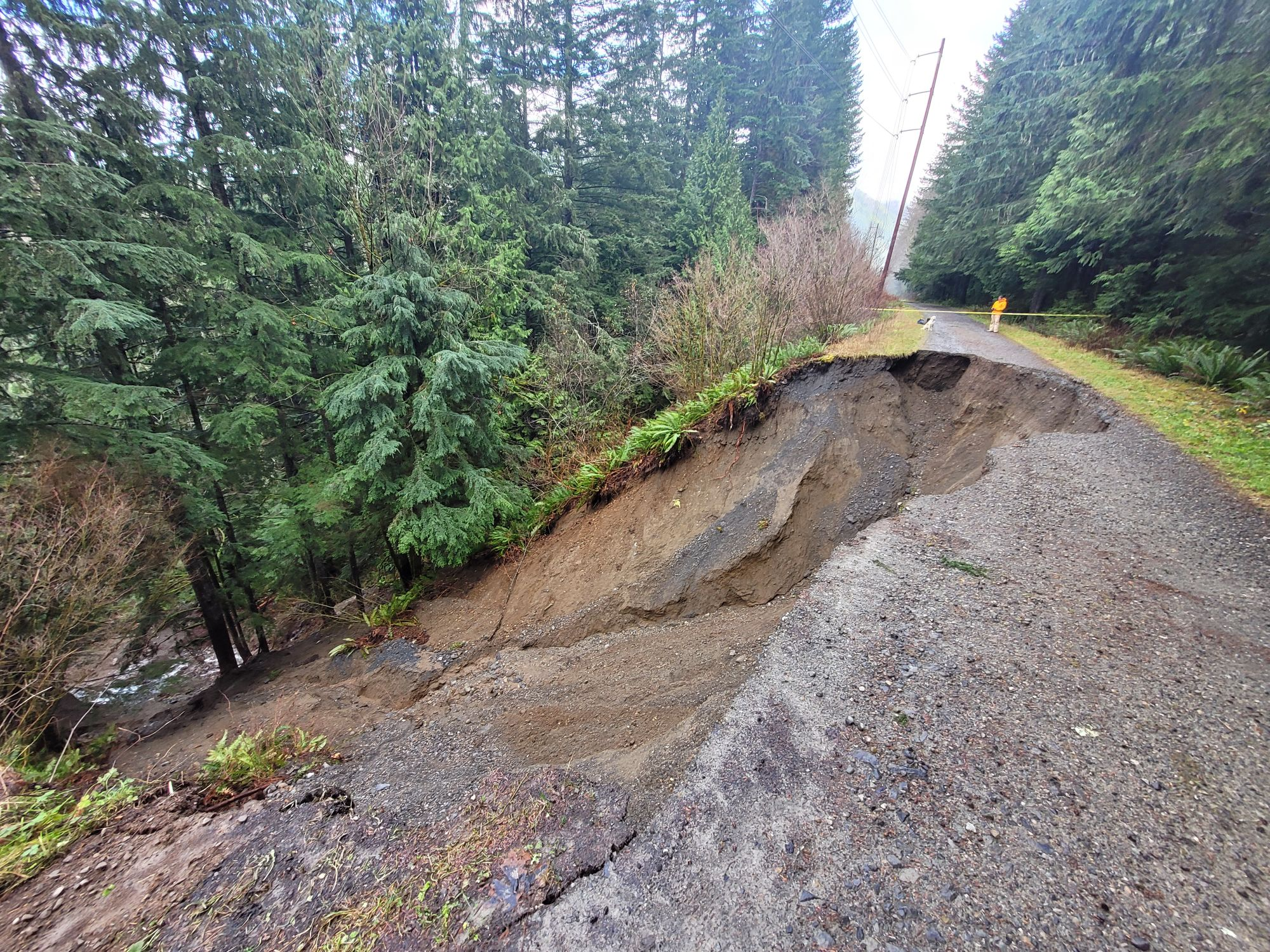
A widely-reported landslide in December 2025 severed the trail between Rattlesnake Lake and the Mt Washington trailhead in Olallie State Park. Initially repair was not anticipated this year. But thanks to Washington State Parks, the Washington State Parks Foundation, Evergreen Mountain Bike Alliance, and King County a temporary bypass is being constructed. The bypass is anticipated to open after June 15.
Additional damage farther up the trail caused a second closure beginning near Carter Creek Campground and extending to the tunnel. Repairs to this section are paused because crews and equipment were diverted for higher-priority repair of severe damage near Lake Easton. A reopening date for the Carter Creek closure is unknown presently.
Until these repairs are finished, riding any permanents that use the trail between Rattlesnake Lake and the tunnel is either impossible or requires unattractive detours on I-90.
04882 – Snoqualmie Valley, Middle Fork, Snoqualmie Tunnel is unrideable because the control at the tunnel cannot be reached.
All other routes on the trail can bypass the closures by riding on I-90. Why a person would want to trade quiet forest and easy railroad grades for miles of proximity to roaring freeway traffic with steep climbing eludes me, but here are considerations if you want to do this: Bypassing the Olallie closure on the freeway shortens routes about 7.5 miles each way. Riders would have to free-route another 15 miles on the out-and-back routes to ride the required distances. National Forest Roads below the freeway bypass the damaged area near Carter Creek. However, a portion of the detour would be on Road 58 which is one-way uphill only. Riding westbound you would have to descend on I-90.
Prior to learning about the second closure and the damage east of the tunnel, two routes starting at Olallie State Park were created, but are moot until all repairs are finished:
05790 – Homestead Valley-Easton on the Iron Horse Trail
05789 – The Shortened Real Northern Exposure
Information about the current condition of this part of the trail is available at the WA State Parks P2C West page.
East of Snoqualmie Tunnel
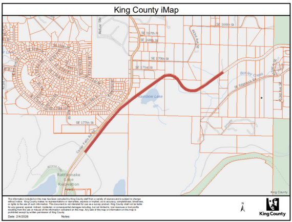
Update 5/3/26: The P2C Central page has been updated to state the trail is still closed from Monahan Rd to Stampede Pass Rd. This is a shorter section than indicated on the map below, but still means you cannot ride from Hyak to Lake Easton.
Update 5/1/26: The closure between Hyak and Lake Easton has been lifted. The state of the trail surface is unknown. Loose gravel has been reported in the Whittier Tunnel.
04509 Cle Elum-Hyak-Cle Elum should be rideable now.
04162 Hyak-Stampede & Tacoma Passes-Lake Easton will be rideable once the high country melts out
The section below is now out of date still relevant.
A landslide on March 23, 2026, east of Hyak damaged the trail, the railroad, and power lines west of Lake Easton. The trail is closed at the west from the Whittier Tunnel (aka Tunnel 49), to the east at Monahan Rd. The only detour is 7 miles on I-90, including a construction zone with skinny shoulders. Repairs in this area are anticipated to be complete around the beginning of June. Recent reports are that the construction zone is rideable, but you should check with the P2C Central office whether the trail is open during work hours.
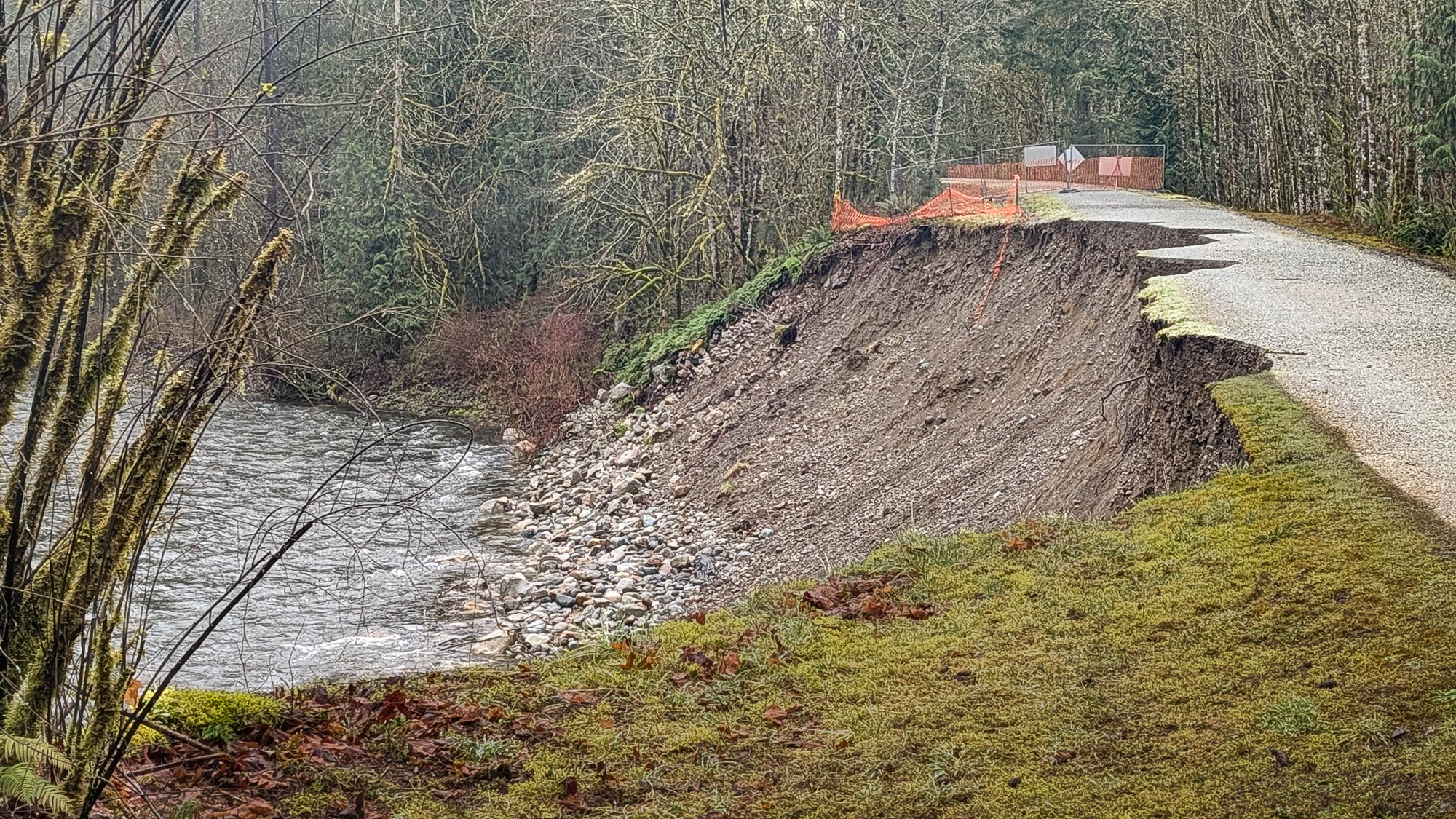
High river flow during the storms in December 2025 scoured and destabilized the embankment that carries the Cedar River Trail about three miles from the trail’s eastern end at Landsburg. The embankment and trail surface have eroded significantly in the last month. The trail will likely collapse soon. Crossing the closed section of the trail is far too dangerous, despite local residents continuing to walk and bike across it.
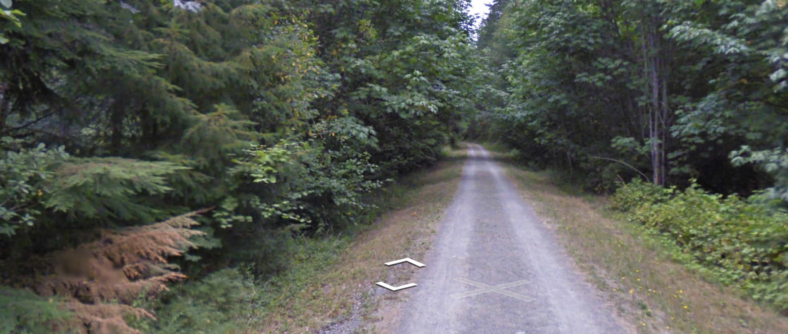
Most people were probably unaware the trail was so close to the river here.
Google Street View
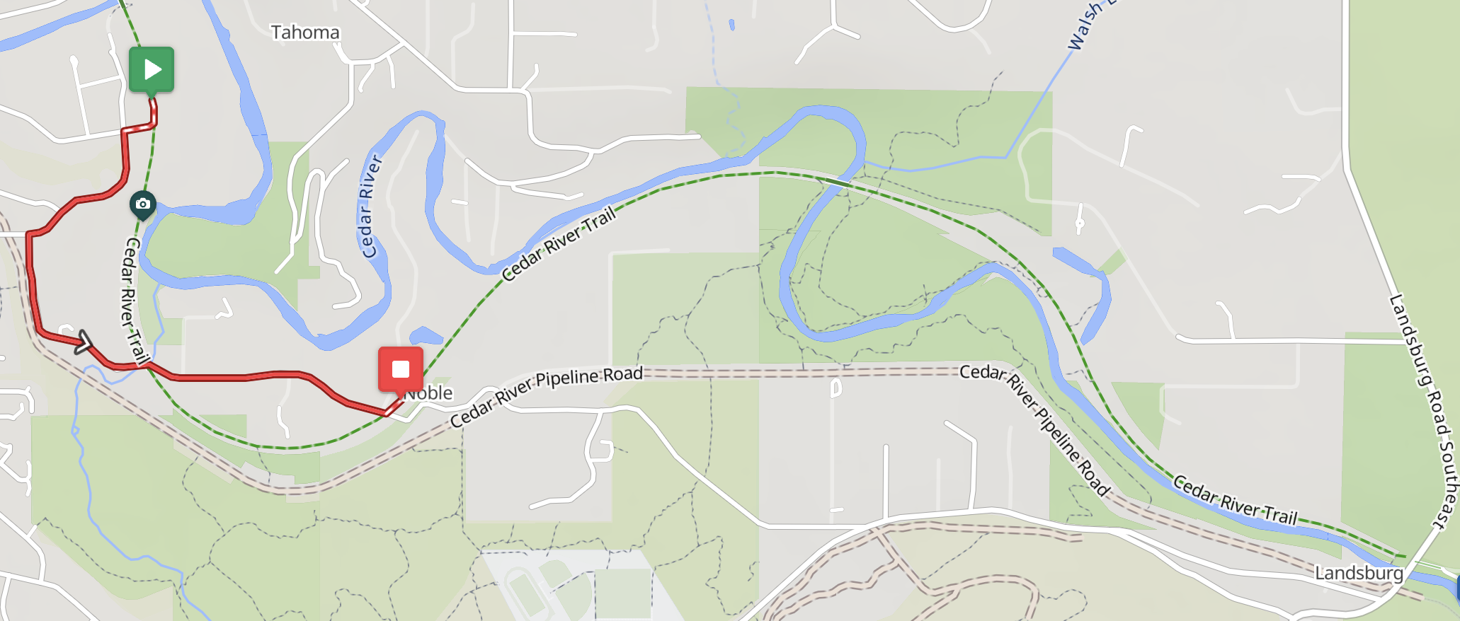
King County has furnished no information about repairs. Given that the embankment is not a levee protecting a flood zone, repairing the trail probably has low priority. Fortunately the damaged section can be bypassed on residential streets:
RWGPS Cycle map
Four permanents have been rerouted. The routes are slightly shorter and lost some gravel credit, but gained a 15% surprise.
0401 Leschi-Auburn-Leschi
0848 Mercer Island-Selleck
1076 Southern Exposure
5709 Cedar River Wilderness Run
Comments Off on Rerouting near the east end of the Cedar River Trail
The last mile or so of the Snoqualmie Valley Trail is closed to bicycles and pedestrians very close to Rattlesnake Lake. The trail is being used for vehicle access to residences on Edgewick Rd while Edgewick is being repaired. Edgewick is not a detour option. The SVT should reopen in early April according to King County.
Detour options are not good. The route beginning with 136th Ave SE at I-90 is strongly discouraged due to extreme grades, poor sightlines, and fast drivers. A safer option is to follow permanent 4078 Snakebit backwards from North Bend. This is a substantially more difficult route than the SVT’s nice railroad grade. The best option is probably to choose other routes while the SVT is closed.
Note that permanents continuing up the Palouse to Cascades Trail (Iron Horse) past Rattlesnake Lake are deactivated due to the serious washout that occurred in December. The rideability of most of those routes is moot anyway while the Snoqualmie Tunnel is closed for winter.
Comments Off on Snoqualmie Valley Trail Closure near Rattlesnake Lake
#04412 Redmond-Golden Gardens, 102.4 km, was contributed by Randy Oakley. Apart from the Missing Link in Ballard, it is entirely on the Burke-Gilman and Sammamish Valley Trails. At 47.8 km the route has a curious left turn onto the Burke-Gilman from Shilshole Ave that involves getting on the right-hand sidewalk along Shilshole. SDOT has done what it could to ensure cyclists make the turn under the protection of the traffic light. Please study the map and execute the turn as intended for your safety.
#4481 Packwood-Paradise-Packwood, 126 km, should be a spectacular route once the wildfires pass this year. Note Stevens Canyon Rd is only open Fri-Sun this year due to construction.
#4454 Southworth-Belfair-Keyport-Bainbridge, 104 km, is a scenic and rather strenuous route with 4200 ft of climbing. If you find this route unchallenging you can move on to:
#4518 Vashon Ramble, 102 km. Finally I worked out a route on Vashon! With 6500 ft of climbing don’t let the name lull you into taking it easy. Note Burma Rd is closed. The closure signs are on the side of road to allow local traffic to pass. Don’t mistake that for the road being passable. It is definitely cut.
Geoff Swarts has been busy constructing a loop around the Olympic Peninsula:
#2342 Four Pass Challenge, 605 km, was reactivated by request. This route climbs Stevens, Old Blewett, White, and Cayuse Passes in addition to traversing the Yakima River canyon.
#4180 Wet Side-Dry Side, 404 km, was updated for the closed trestle on the Issaquah-Preston trail.
Farther Afield
If you are feeling mildewed this winter consider my new routes in Death Valley: