Cue sheets sometimes fail us, whether because of errors and omissions by the ride organizers or because our navigations skills let us down.
Many riders (including me) have started to use GPS units to supplement or replace their cue sheet navigation. They have their own issues, of course, including the need to keep them charged for an entire ride.
For what it’s worth, I’ve been experimenting with a smartphone-based backup for navigation. I use it as a fallback if both my GPS and my cue sheet fail me. For non-GPS owners it could just be a backup to their cue sheet navigation. Someone suggested that I post some details about it online, so here it is.
The idea is to combine off-line maps preloaded into the phone, a track of the route preloaded into the phone, and the GPS capabilities of the phone.
The value of having off-line maps is to provide street-level information when the phone has no access to cellular signal (or when cellular data is switched off to save money when traveling out of the country). I use an app called MapsWithMe on my iPhone. There is a free version, but I paid a few bucks for the full version. Versions are available for Android and Kindle as well, but I have no experience with them. A recent update to the iPhone app added the ability to import a KML file which helps with the second piece of the puzzle.
The next step is to load the track of the route into the application as well. My preferred method to do this is to use an online mapping application like BikeRouteToaster or RideWithGPS to create a track from the ride’s official cue sheet. Often the ride organizers will publish an unofficial GPS file, the pre-ride volunteers will offer one, or someone that I am willing to trust has created one. In those online applications can usually be found an option to download a GPX file that shows the track of the route. Once I have a GPX file, I go to a website that will convert the GPX to a KML file, viewable in the MapsWithMe application. The site I use is gpx2kml.com. Then you need to get the KML file into the phone. Dropbox or email does the trick with iPhone.
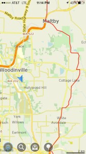
Now, if I find myself lost or doubting my navigation, I can open the app on the phone and locate myself on the map. If all has worked, I should be able to see my position (represented on the iPhone by a blue dot), the streets around me, and a line represented the course. If I’m off course, perhaps that’s enough to get me back on course. Or maybe enough to ask a kind stranger to help.
Hope that’s helpful. Questions, better ideas, other thoughts welcome in the comments.
Mark

Wowee zowie! I exported a .kml file from RideWithGPS, emailed it to myself, and there it was! (skipped the gpx to kml step). Thanks Mark!
Thanks for the Info Mark
I opened the KML file by attaching to email to myself. I opened the attachment, then clicked on the icon at the top right that permits sharing and other actions. I chose Open in MapsWithMe. Then it showed up in Bookmarks with the heading Converted from GPX file.
I’ve attached to the original post a sample screenshot that shows a route track in red and my location with a blue arrowhead.
This would be totally cool! Does the track from the kml file show? The manual doesn’t exactly say. When you load a kml file, is that through the bookmarks feature?