Debra Banks originally posted this ride report on the Rivet Cycle Works Blog. Debra founded Rivet to design and sell saddles for endurance cycling.
SIR 1240k
by Debra Banks
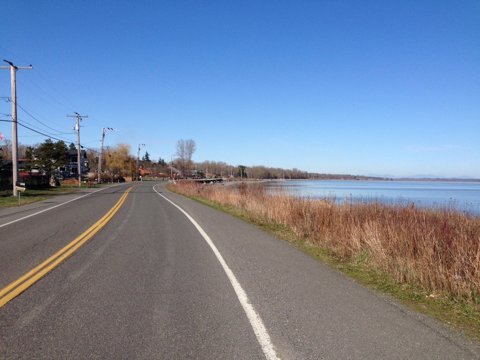
It’s summer and that means longer rides. I have signed up for three 1200k brevets (not exactly sure why I have, but hope to figure it out while riding them) and the first is the Seattle International Randonneur’s (SIR) Cascades 1240k or 770 miles of bliss cycling around Mt Rainier, with abundant views of sibling volcanoes, Mt Hood, Mt Adams and Mt St. Helens. It’s beautiful countryside – the ride description promises mountains, desert, and hills. Plenty of hills.
I was up in WA earlier this year for SIR’s Crank and Brevet Week, and had a delightful if not windy time, so I was familiar with some of the landscape and the way in which the SIR folk’s design rides. They are… well, hard. This year’s edition of the Cascades 1200k was longer and had more climbing than the last two versions. Day one is longish and hilly, day 2 is longer and a bit less hilly, day three is our recovery day crossing the desert and day four is longer, but mostly downhill after passes in the early AM. We have 94 hours to complete the ride.
The big question prior to the ride was: Fenders? No fenders? SIR rando’s almost always have their fenders on their bikes – at all times. It rains up there. A lot. Fenders and wool, two things you can count on with an SIR rando. The weather kept reporting only a 10% chance of rain during the ride. It seemed like the weather gods were smiling on us, so after consulting a crystal ball and a tarot card reading, most of the out-of-towner’s skipped fenders.
Riding buddy Drew and I drove up the night before and met another rando-pal for dinner at his place in Seattle. We moved on up the road to the start and settled in after the hotel had given away our reserved room. After a bit of wrangling, we got ourselves set up for the oh-dark-thirty-wake-up and start.
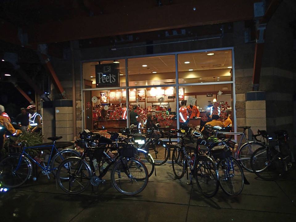
Day 1 Monroe to Carson
Distance: 358.8 km
Elevation: + 3846 / – 3807 m
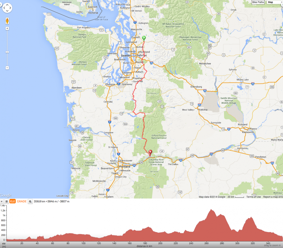
Day 1 – Monroe to Carson Hot Springs
Up early and out the door, the start is a block away. I realize I have forgotten my water bottles, (had to be something) but this is minor. Two are quickly offered by SIR fellow randos – Thanks Shan and Michael! I see SIR friends and a bunch of SFR randos are in attendance for our cycling adventure. A few friends from Australia have also made the trip: I ran into Peter Donovan in the elevator, who’s home I went to for a post Sydney-Melbourne BBQ, and then on my way to the bathroom, walked right in to Danny, a very fast rider from Western Australia, who I lent my wheel to last October so he could finish Sydney Melbourne after I had DNF’d. The rando world is very small AND holds a very great group of folks.
Mark (the head of SIR) tells us to be careful and as we ride out, he yells to me to keep the rubber side down. I’m only a week out from having crashed hard on a gravel ride, La Ruta Loca Rando in the Marin hills. I am smothered in vitamin E oil, to help keep the wounds moist and on the mend. Nothing hurts while pedaling (yet) so off I go.
The group moves on down the road and there is a lot of chatter amongst the riders. I have already missed a light, which splits groups into smaller units, and I think I won’t see those folks until the rest stop this evening – 230 miles away. The weather is cool, no wind and the company is good. It’s a nice day for a bike ride. We easily move on down the road.

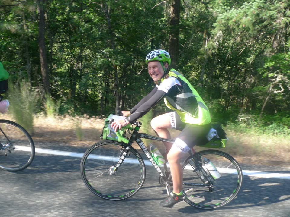
Drewski rides by with Mt. St. Helens in the distance. Photo: D. Banks
At some point, Asta Chastain, a very fast rider from SIR who lives in OR is in my little group. We hopscotch with each other and decide to hang with each other in our small rando posse. I have been on the same ride as Asta a few times, but rarely ride with her. She is much too fast for me, but today she wants to ride with us slower (and older) people, and she’s a pleasure. We talk about outdoor education and MBTI scores. It’s fun to get to know each other while riding along and she’s cheery and has a fast yet steady wheel.
Asta on the Green Machine. Photo: E. Larson
Somewhere down the road we stop at a control and there is GP. I thought I’d be riding with him, but we had gotten separated at that first light. He says he’s burned some matches riding with the “fast boys” and I tell him to hang with us, we’ve got Asta! We’re not the slowest and we have plenty in the tank for what’s still to come.
Which is a really beautiful climb up into a forest that then traverses the mountainside providing stunning views of Mt Adams. It is really pretty and as the miles tick by we are graced with a great forest service road and a really nice ride. It drops us at a control where we tank up for the last work of the day, eating ice cream, chips and Drew has his first beer of the day. We ride up and over Elk Pass, which isn’t pleasant, but we get the job done.
Up next is Oldman Pass and it seems to go a bit easier. The descent is fast, and now it’s dark. We make our way down and I am reminded of one of the final stretches this past Spring in Wenatchee, when I didn’t know how long it was to the end and I kept thinking to myself, “Is it now? Around the next bend? Now? Where the heck is the town?” at some point every day, you are just ready to be Off. Your. Bike.
Finally we reach Carson Hot Springs, and there to greet us is the smiling face of Susan Otcenas and her merry band of rando-volunteers. Asta has assured us that Susan has bought good beer and there will be a lot of it at the control. We check in, take showers and drop into the dining room to eat. There is beer, but not anything close to good stuff. I buy two Bud Lites (pathetic!), and pass one to Drewski, who says, it’s better than nothing…but just barely better than nothing. It does the trick, we sleep, for 6 hours! A first for me.
Day 2 Carson to Ephrata
Distance: 369.3 km
Elevation: + 3377 / – 3086 m

Day 2 – Carson Hot Springs to Ephrata
We depart after a hearty breakfast. We are among the last to leave, the fastest folks can sleep longer as they will pass us. The slower folks have had less sleep and they are gone. It’s Sunday and we are in need of some caffeine. The cafes are closed; it’s too early for them to be open. In the meantime, we ride along the Columbia River and I realize we are across from the town of Mt. Hood, Oregon. We have already ridden from the outskirts of Seattle to the Oregon border. Mt. Hood is in the distance and town is right across the river. It’s a great town – I was there mountain biking a number of years ago. Super fun riding – much of it over my skill level.
We are on a flattish road and I am ticking out a pace to make some time. We start to skip past some of the other folks who left earlier, but who are operating on less sleep.
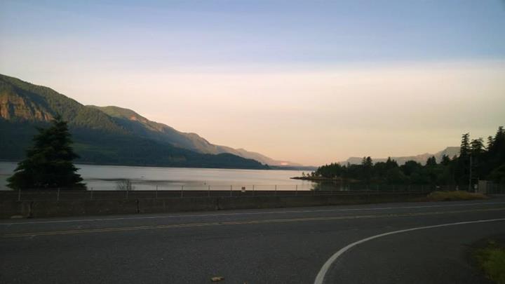
Looking across to Oregon on the great Columbia Morning breaks – day 2. photo: P. Auriemma
It’s one of the funny dynamics about randonnuering. If you are fast, you complete the day faster, which gives you more time to sleep. The more sleep you have the safer on the road you are. If you are slower, you take longer on the road and end up getting less sleep, which means you will be sleep deprived on the ride, which adds challenge and raises safety issues. There are some people who like to ride on minimal sleep, but I’m not one of them. I want to get as much sleep as possible, and by that I mean 3 hours if I’m lucky (which as I write this, doesn’t sound like much… and… it isn’t). I’ve worked harder this past year and have gotten a bit faster, which has yielded more sleep, and so to get 6 hours on the first night is HEAVEN!
Still sleep does not help when what you want is coffee and we are on the hunt for some in the early morning on Sunday. Our day is longer today, but has less climbing, and our small group is feeling pretty good. We stop in a small town past our turn to get some coffee and run into a couple of others who have the same idea. Ron Himshoot, a strong rider is leaving as we are drinking on the sidewalk, and he takes a wrong turn. GP yells to him to turn around. Then Ron turns up a driveway and is again going in the wrong direction, and GP again rights him. Finally, after much, confused route finding, he disappears in the right direction.
We get up to leave and the group takes off without me. I see a backpack sitting against the wall. I pick it up and find out that it is Ron’s. His brevet card and wallet are present in the top pocket. No brevet card, no credit for completion. I shoulder the backpack and scurry to catch up to my riding partners. Almost to them, I am cresting a hill and Ron zooms back our way.
“I’ve got it!” I yell to him and he stops. “ I realized it wasn’t there when I went for a sip of water out of the Camelbak”. He shoulders his load and says, “I’m having a bit of a low point here.” It will change, that’s one thing you can count on when riding these distances. Sort of like the weather. He asks me what kind of beer I like and I tell him IPA. “Alright”, he says and starts to trudge back up the hill.
I get up to our group and we head on. The topography is amazing. We climb out of the Columbia River Gorge and up onto a high plateau. The land is golden with wheatfields, and views of Mt Hood and Mt St. Helens are visible. The coffee has kicked in and we are enjoying the miles.
As the day wears on, the land heats up and we arrive at the control hot and hungry. Everyone is regrouping inside the air-conditioned fast food store, downing soda’s filled with ice. We tank up, as the next section is hard and exposed and it will be hot.
This section is rollers with an upward trend. They keep going and going and going. At one point, we top out on a longish climb to see the road traverse around the hillside losing all of the elevation we have just earned, and then it climbs back up re-gaining all of the elevation. Ugh! Who thought up this engineering feat?
We continue onward and upward. Today feels harder than the day before. Maybe it’s because we are already somewhat fatigued, or maybe it’s the heat, but getting to the Bickleton control is really tough. Once we are there it is an oasis. Ice cream, fresh strawberries, soda, cookies. The SIR volunteers are there with big smiles and helping hands. The locals are inside the store watching us in the midst of our weird processes – collapse on bench, rally for the bathroom, sit again and rest, re-fill water bottles, eat, rest. Rally to leave…
A number of rando’s throw in their cards in Bickleton, and abandon the ride. They are too spent to continue on. Our group carries forward. We drop down into a valley that we will cross and stop for another break. It is really hot – well into the 90s. Manny comes into the C-Store and looks absolutely trashed. “Would you all be willing to go 12 MPH and give me a pull”, he asks? “I need a break, but need to keep going”. We saddle up and put Manny in the middle. It’s hard to go slower, but he needs the rest (he’s only had an hour or two of sleep) and he’s asked for help. Of course, we’ll aid if we can. We scoop up another rider from British Columbia and Jaime stays with us the rest of the day into night.
We usher Manny to the next climb and then leave him to his own cadence and continue on. We make our way again down to the Columbia River. It’s wonderful to cross the water. The air is cool, a fly hatch and swarms of small flies are circling themselves like a mini-tornado, and the sun is setting. We head up a hill where a friend of mine severely bonked during the last edition of the ride and I think of Irene. There are large, very weird Mormon crickets on the road. They look pre-historic and give me the creeps as they hop around.
On the other side we continue on across the valley towards the next ridge. We’ll head there and then turn left, continuing onto the control. I flat and fix it, our group of riders strings out and regroups. It is well into night by the time we reach the control, and again we are welcomed by the SIR volunteers. Thank you Bill’s Gobie and Dussler and crew. Cup of Noodles, ravioli, soda, coffee, water, cookies, fruit. I want everything and nothing.
We still have 50 miles to go until the sleep control in Ephrata. It feels like forever to get there. We paceline as a group and now small things are irritating. Someone’s rear light seems to shine directly into my eyes, another person can’t hold a straight line and is wobbling all over the road. I’m sure I am doing something aggravating too. We ride in silence managing the irritations, but thank everyone for each pull they do as it brings us closer to Ephrata. We are all tired.
We have been passed by a strong rider from SoCal. His red blinky is way off in the distance, and I keep an eye on it. We are in the midst of endless rollers and that blinky keeps dipping in and out of sight. Most of us stop for a nature break or to adjust something, but GP heads off to catch up with me. I am behind him on the side of the road peeing, but he thinks I am somewhere between our group and the blinky. He kills himself catching up to the SoCal blinky, and he does, only to find out that I am back with the group. Oops!
We come by and scoop GP back up into our posse and finally reach Ephrata. There are still people trickling in as we eat and crash. Manny arrives just as we are turning in for a 4 hour sleep. Tomorrow is our “rest” day.
Day 3, Ephrata to Mazama
Distance: 231.1 km
Elevation: + 2597 / – 2334 m
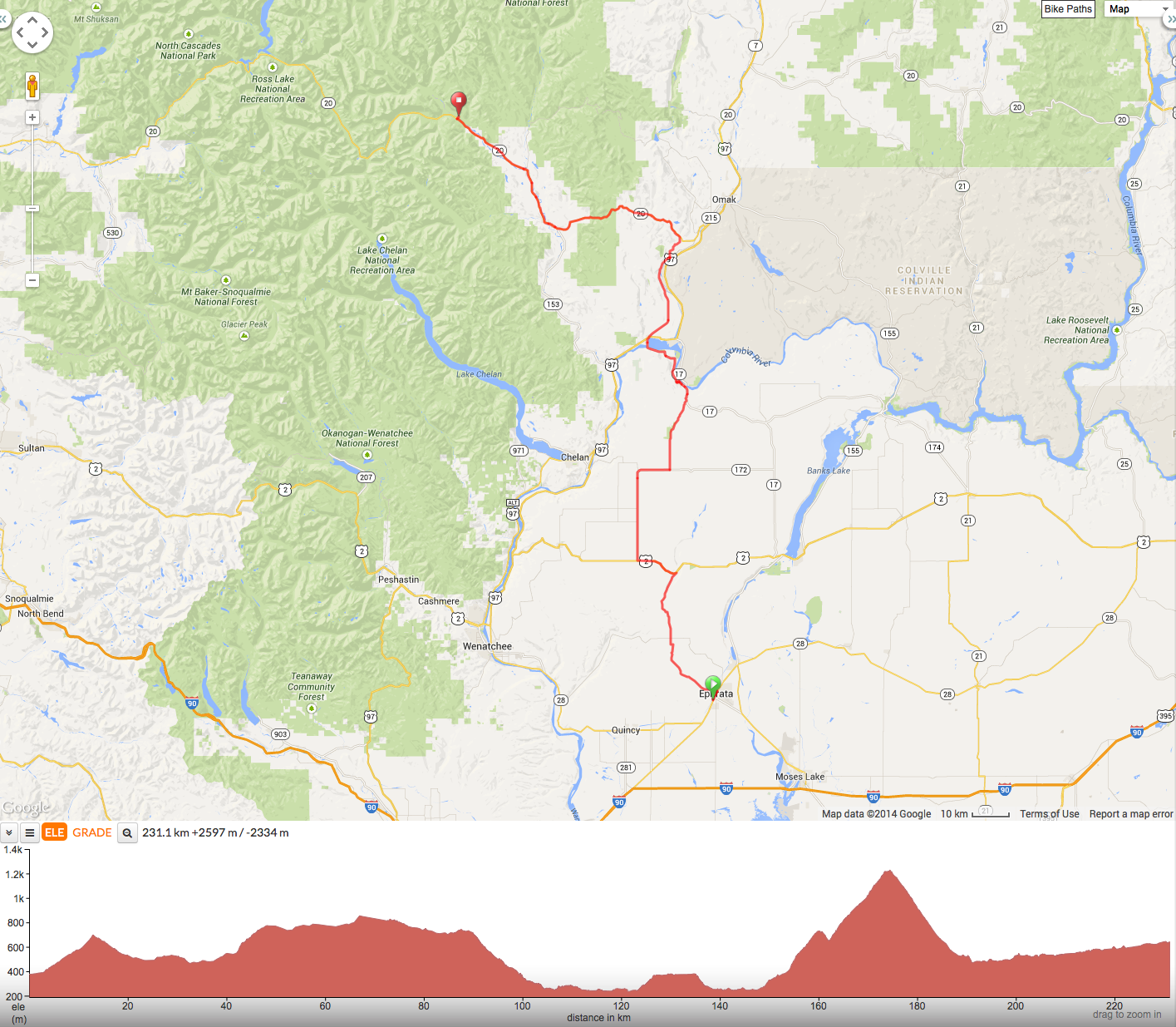
Day 3 – Ephrata to Mazama
Up and out by 7:00 AM, today is the “rest” day. Only 150 miles! Woot! We have thought that if we survive days 1 & 2, that there’s a good chance we’ll make it to the finish. We saddle up and head out into the sun. The morning brings us onto roads I traveled in April during the SIR Brevet week. We stop in Farmer at a fabulous community hall and sit inside in the cool shade, joking with fellow riders.
Drew, GP and I are strung out a bit, but stay together throughout much of the day. We have climbed up to the Moses Coulee; a high plateau of wheatfields. As far as the eye can see are golden waves of grain… We drop down to the Columbia River after taking a quick look at Chief Joseph Dam, and head to Bridgeport for lunch. We relax in the shade in a park and hang out. It has gotten really warm as we climb out of the river valley. Heat and lack of sleep is starting to take a toll.

Miles of wheatfields. photo: D. Banks
We continue on to Malott and stop in the shade where the SIR vollies have set up shop. The help and support of this group is outstanding. They are smiling and cheerful (which boosts me enormously) and while chatting with us, I can tell they are checking us out to see what kind of condition we are really in.
The last piece of the day is to climb up and over Loup Loup pass. A long sustained climb that will drop us into the Mazama and Methow river valley. GP and I take our time but Drewski gets after it. We will see him at the sleep control in Mazama. I’m not a fast climber, slow and steady, but I love a great downhill. The SoCal blinky guy is up the road and we stop to talk with him. While doing so a cub and mother bear cross the road about 200 yards down and away from us. Very cool.
GP heads up the road, while I continue my steady slog. SoCal blinky guy sticks with me and we chat our way to the top. I sit down on the ground for a rest, but GP is urging me to move along. I snap at him, “I pulled you all the way to Malott, so I will sit here and have a break”. I eat half a sandwich and pull on clothes. In the meantime Ron Himshoot has joined us at the top of the pass.
We start down and just as we are picking up speed, a female moose pops out of the forest and stands by the left-hand side of the road. GP slows way down, me too. They are some of my favorite creatures, and they spook easily. Not something you want to hit, or have come at you. While we are sizing the moose up and the moose us, Ron comes barreling by yelling, “Don’t scare the moooooose!”
She disappears.
It’s a fun descent and at the bottom we are in a lush valley at the foot of the Cascades. GP and I hope to make it to the supermarket before it closes, but we miss it by a few minutes. We take the scenic road around the valley and as the sun sets, we cruise by farms and homes, corrals and gardens. Bucolic.
In Winthrop, I need a break. I’m starved and am running on fumes. We still have about 25 miles to go, so a break is in order. Unbeknownst to us, the wind picks up and of course, it is a pretty good headwind for the last stretch of riding. Trading pulls we make our way, stopping on a bridge at some point to get some relief from the wind. There aren’t any blinky’s in the distance to help us tonight and we slog to the control. Felt like it took forever to reach the Mazama Resort, and it’s too bad we didn’t get there early enough to enjoy the “rest” day, because the resort is exactly that, a full on resort. Hot tubs, pools, bar… Sigh. We eat and drop into bed.
Day 4. Mazama to Monroe.
Distance: 280.5 km
Elevation: + 2507 / – 3109 m
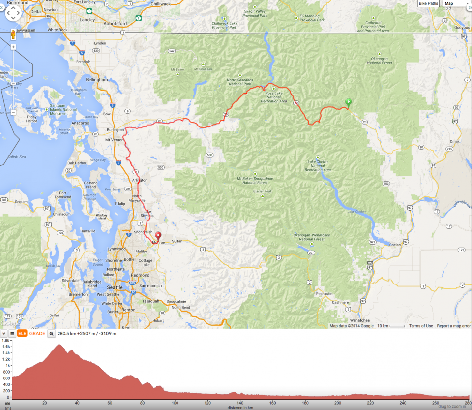
Day 4 – Mazama to Monroe
Breakfast is a feast. Everyone is in great spirits, we are finishing today. We chow down and head out… into a light rain. Dammit! No fenders.
No matter, we are climbing up to Washington Pass in North Cascades NP and it is beautiful. Big trees, left over snow, waterfalls, mist and a ribbon of road that disappears between cliffs. Sure our legs are sore and progress isn’t fast, but it’s so pretty that the pain is dampened. Up, up up, and through to the other side’s downhill. Another bump up and over a second pass.

Heading up to Washington Pass – AM on Day 4. photo: D. Banks
We stop there to put on more clothes and an elder couple is walking along the road. They say hello and stop to chat with us.
“Ten years ago, we walked the entire Appalachian Trail. It took us 6 weeks.”
“That’s fabulous”, I say. “Do you mind telling me how old you are?” (they look 70ish)
“Sure, I’m 84 now”, says the woman.
Her husband adds, “She’s my older woman.”
She blushes, I’m three days older.”
“She’s my Cougar!” he blurts out with pride.
We all laugh.
How great is that?
Back on our bikes, we head on down the pass and lo and behold, there again are the SIR volunteers. They have stopped on the side of the road and set up a makeshift coffee stand. Bill D. hands me a French pressed coffee with half and half. Fabulous. We hang and chat, and I retell the story of the lovely couple we just met.
We need to continue on down the road because Monroe isn’t getting any closer, so we meander down the valley. There is water everywhere. Big waterfalls cascading off of cliff shelves (I’m guessing this is how the park came to be named?), dropping tons of water into the river, which is at near peak water levels. I watch the torrent below, trying to pick the correct line as if I were boating it in a kayak.
The water flows into the large dammed Lake Diablo surrounded by peaks. The water is aqua colored – glacial silt making it that special cold color. Three valleys extend in different directions here and we head downward out and towards Newhalem and flatter topography. Really, really, beautiful.
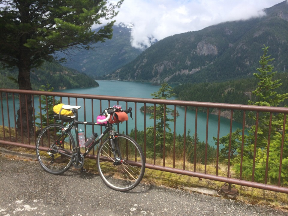
The new Dragonfly with a new Indy pose by Diablo Lake. photo: D. Banks
Drew has gone ahead, so it’s GP and me riding along, heading to Monroe. We stop for lunch at this whacky old style hamburger place in Concrete. Really? The town is called Concrete? Says so on the water tower…. Really?
The route goes across the Skagit River and winds down a tree tunnel. We stop for a 10 minute powernap on the concrete slab of the fire station. Good thing too, because 5 minutes after we have started to ride again, we are chased by a mean-sounding dog. I pick it up, and GP is left to fend for himself.
At the final control, we eat and have a beer. There are rando’s there who are relaxing before the final push back to Monroe. Manny and Glenn are there, Drewski and Phil have recently departed. We have about 50 miles left, and we have a beer and a cup of coffee and are on our way. The last 30 miles is on a bike path and we mosey along. I am fading and my stomach is upset, so we stop for a ginger ale and crackers.
Finally, we reach Monroe. We have finished in 90 hours, right around midnight. Asta, Drew, Phil and Ron Himshoot are there eating pizza, waiting for riders to come in. Ron hands me a paperbag, In it is a note and a large IPA! Woot!
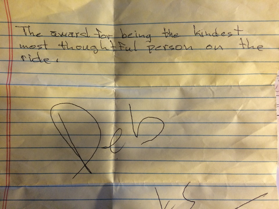
In the bag along with a Ninkasi IPA. Woot!
I would highly recommend it if anyone wanted to do this ride as a tour. Three or four days would be a lovely pace and you’d get a chance to really enjoy the scenery. And for the rando’s out there – put this ride at the top of your list. It is a beautiful ride hosted by a great club. The SIR folks were top notch.
Many thanks to those I rode with: Drew, GP, Glenn, Phil and Manny, who completed his first 1200k. To the SIR organizers and volunteers – you are total ROCK STARS! You all seemed to be everywhere with helping hands, warm smiles and good cheer – at all times. To Shan and Michael for loaning me water bottles in a pinch. To Phil A. And Eric L. for letting me crib some photos. And, as always, thanks for reading.


