Update 5/2/26: The closure east of Hyak is still in place.
Update 5/1/26: The closure east of Hyak has been lifted.
For us on the west side of the Cascades, riding season on the Palouse to Casades Trail traditionally starts with the Snoqualmie Tunnel opening on May 1. But randonneuring season the trail will be delayed this year. The P2C trail suffered impassable damage in several places during the ’25-’26 winter. Initially the outlook was dismal; significant repairs were not expected to be possible this year. Fortunately major work is underway. The full trail should be rideable later in summer.
Rattlesnake Lake to Snoqualmie Tunnel
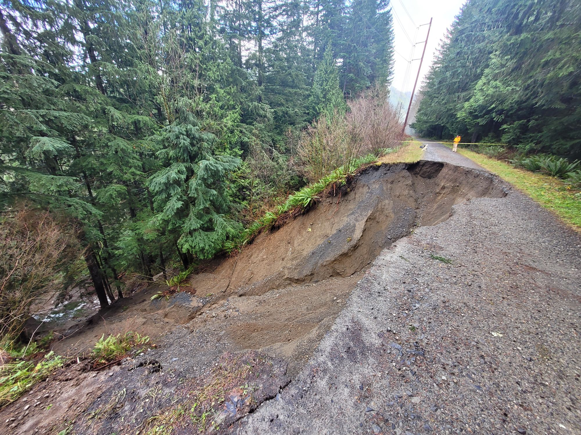
A widely-reported landslide in December 2025 severed the trail between Rattlesnake Lake and the Mt Washington trailhead in Olallie State Park. Initially repair was not anticipated this year. But thanks to Washington State Parks, the Washington State Parks Foundation, Evergreen Mountain Bike Alliance, and King County a temporary bypass is being constructed. The bypass is anticipated to open after June 15.
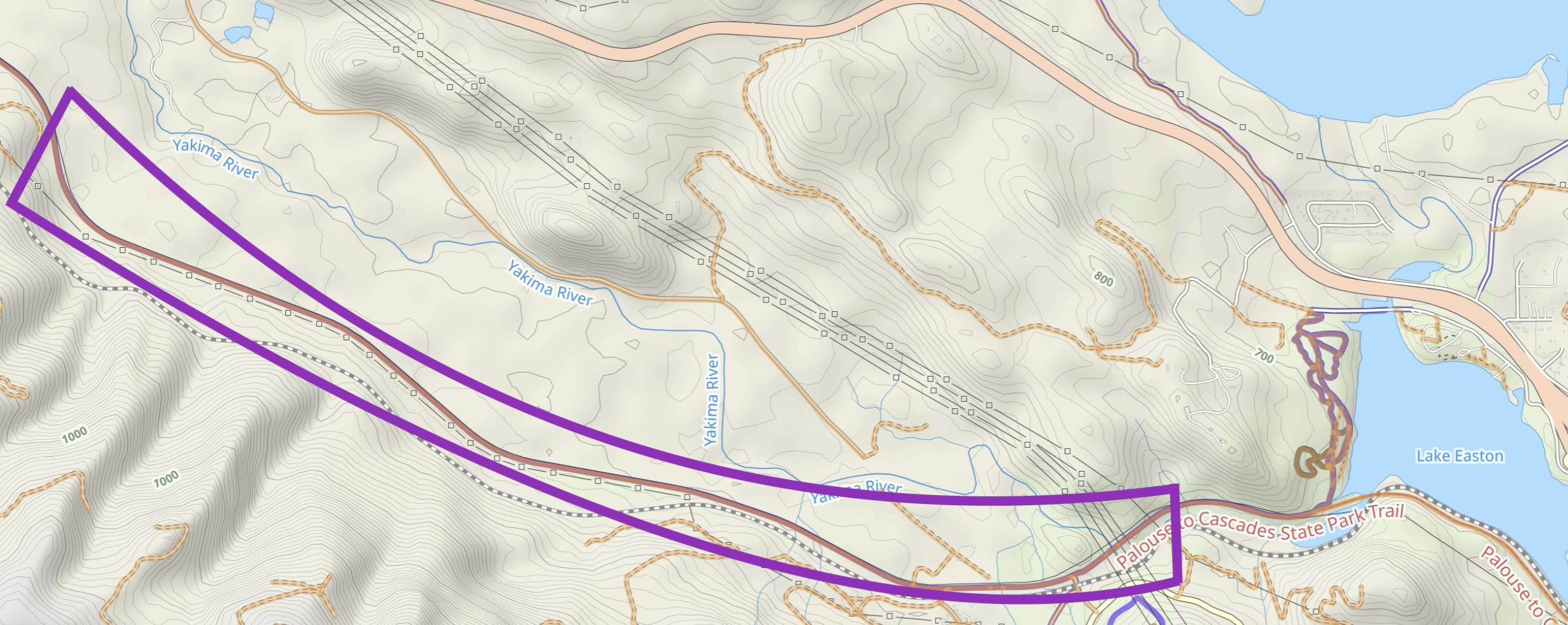
Additional damage farther up the trail caused a second closure beginning near Carter Creek Campground and extending to the tunnel. Repairs to this section are paused because crews and equipment were diverted for higher-priority repair of severe damage near Lake Easton. A reopening date for the Carter Creek closure is unknown presently.
Until these repairs are finished, riding any permanents that use the trail between Rattlesnake Lake and the tunnel is either impossible or requires unattractive detours on I-90.
- 04882 – Snoqualmie Valley, Middle Fork, Snoqualmie Tunnel is unrideable because the control at the tunnel cannot be reached.
- All other routes on the trail can bypass the closures by riding on I-90. Why a person would want to trade quiet forest and easy railroad grades for miles of proximity to roaring freeway traffic with steep climbing eludes me, but here are considerations if you want to do this: Bypassing the Olallie closure on the freeway shortens routes about 7.5 miles each way. Riders would have to free-route another 15 miles on the out-and-back routes to ride the required distances. National Forest Roads below the freeway bypass the damaged area near Carter Creek. However, a portion of the detour would be on Road 58 which is one-way uphill only. Riding westbound you would have to descend on I-90.
Prior to learning about the second closure and the damage east of the tunnel, two routes starting at Olallie State Park were created, but are moot until all repairs are finished:
- 05790 – Homestead Valley-Easton on the Iron Horse Trail
- 05789 – The Shortened Real Northern Exposure
Information about the current condition of this part of the trail is available at the WA State Parks P2C West page.
East of Snoqualmie Tunnel
Update 5/3/26: The P2C Central page has been updated to state the trail is still closed from Monahan Rd to Stampede Pass Rd. This is a shorter section than indicated on the map below, but still means you cannot ride from Hyak to Lake Easton.
Update 5/1/26: The closure between Hyak and Lake Easton has been lifted. The state of the trail surface is unknown. Loose gravel has been reported in the Whittier Tunnel.
- 04509 Cle Elum-Hyak-Cle Elum should be rideable now.
- 04162 Hyak-Stampede & Tacoma Passes-Lake Easton will be rideable once the high country melts out
The section below is now out of date still relevant.
A landslide on March 23, 2026, east of Hyak damaged the trail, the railroad, and power lines west of Lake Easton. The trail is closed at the west from the Whittier Tunnel (aka Tunnel 49), to the east at Monahan Rd. The only detour is 7 miles on I-90, including a construction zone with skinny shoulders. Repairs in this area are anticipated to be complete around the beginning of June. Recent reports are that the construction zone is rideable, but you should check with the P2C Central office whether the trail is open during work hours.
You can find current info this part of the trail on the WA State Parks P2C Central page.