With the growing number of revived permanent routes, it can be difficult to notice recently added routes on the overview maps. Going forward I intend to publicize routes added in the preceding week or so.
This week two routes were added:
With the growing number of revived permanent routes, it can be difficult to notice recently added routes on the overview maps. Going forward I intend to publicize routes added in the preceding week or so.
This week two routes were added:
Comments Off on Recently Added Permanent Routes
Filed under Permanent Change, Permanents
Beginning October 1, RUSA will allow permanents up to 600 km. A link to an overview map of 300 km and longer routes has been added to the SIR Permanents page. Initially these local routes are available:
02576 Lake Forest Park-Big Lake. 300 km. This route was the most frequently ridden of SIR’s 300 km routes, with 26 completions, accounting for 27% of 300 km rides in the last four years of the old perms program.
00751 Bremerton-Elma-Rainier-Seattle. 300 km. This is likely the flattest 300 km route in SIR’s collection. Most of it is on pleasant low-traffic rural roads and bike trails. If you live on the Seattle side of the sound, riding it in the Bremerton to Seattle direction means you don’t risk missing the last ferry home.
00592 Bainbridge-Hurricane Ridge-Bainbridge. 306 km. This was formerly a sub-300 km route. Modernizing the route to use the Olympic Discovery Trail and avoid the frequently crowded section of Hurricane Ridge Rd below the entrance station pushed the distance up to 306 km. Cap your season with this route!
No 400 or 600 km routes are ready yet.
Comments Off on Longer Permanents Opening in October
Filed under Permanents, Uncategorized
I have tried to pull together everything you need to know about the revived Permanents program. On the SIR home page select the menu item Rides>Permanents.
Also, Yogy Namara has come up with better maps of Permanents, linked on the updated page. The maps on the SIR Ride with GPS home page announced in the previous blog post have been replaced with these maps. The advantage of these maps is they pull routes from the RUSA route library, rather than SIR’s. The new maps always display the official version of routes, rather than depending on SIR’s library being synchronized with RUSA’s.
Comments Off on SIR Site Permanents Page Updated
Filed under Permanents, Uncategorized
If you have registered for a permanent since the new national system started up, you know searching for a route is a bit inconvenient.
If you want to find a route using a map, from the main RUSA page you can pick the Permanents drop down menu and choose Route Search. On the next page click Search for permanents on a map (created and supported by Jake Kassen). Jake’s search will show you routes that are currently available in the new program. Unfortunately it only plots start locations. It does not show where the routes go.
Until the national site displays maps of routes, the SIR team is using Ride with GPS’s Events facility to show you SIR’s routes. For technical reasons a few of the routes displayed may not be active yet in the national system.
Go to SIR’s RwGPS Club page. Click on the Events tab. (You might want to bookmark the events page.) On the left we currently have three groups of Permanents to view: all of them, 100s, and 200s. Click on the set you want to view. It takes a few seconds for the set to load. In the future we might further subdivide the routes by region to keep this process from becoming too slow.
The routes are listed on the left. The selected route (green highlighting) is displayed on the map on the right. To see all the routes at once, click on Show all on map at the bottom of the list. You might have to scroll the list down when we have more routes available.

Now the map will display all the routes.
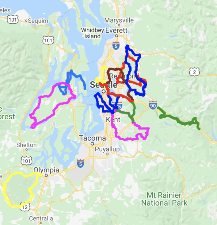
The various colors just distinguish the different routes. If you mouse over a route in the list, its trace on the map will highlight black.
Thanks to Yogy Namara for realizing Events could be used for this purpose, and keeping the lists of routes regularly updated.
Comments Off on Maps of SIR’s Permanents
Filed under Permanents, Uncategorized

The new permanents program starts up August 1st. Changes from the old program include:
Administrative aspects
The program is run on a national basis.
Ride registration and result reporting is online.
Routes are no longer locally “owned.” Route contributors will likely stay engaged with their routes for maintenance, but they will have no administrative role – no longer processing ride registrations and results.
There will be an annual fee.
Changes for riders
Getting started
You need to create an account on the RUSA site. Use the link in the upper right corner. Once you have an account you will access Permanents through the My Account link.
There is a fee of $10 to cover the remainder of 2020. (Not live as of 7/29)
Registering for a ride and reporting results
Registration is online (not live yet as of 7/29).
The registration page will have methods of searching for routes.
You will report your ride result online (not live yet as of 7/29).
Ride results are self-verified – you will click a button to promise you are truthful.
Proof of passage materials should be retained for a year in the unlikely event of a RUSA audit.
Proof of passage options
You may choose to take photos at controls, record a gps track of your ride, or use a traditional brevet card. Information controls are eliminated.
Photos: Controls will have brief instructions specifying what to photograph. At a business photograph the front of the establishment if not otherwise directed. The time embedded in a photo’s metadata is adequate for establishing when you reached a control.
GPS track: Alternately you may record a gps track of your ride.
Brevet card: Or you may use a traditional brevet card, noting times of arrival yourself.
Only the overall elapsed time matters. Intermediate controls are no longer timed. For convenience the time limit is listed in the last cue of a route, and sometimes the first as well depending on the route contributor.
Route materials
The primary route document is a Ride with GPS file. If you want a paper route sheet, you will have to create your own using RwGPS’s printing options. (There are other methods, too, discussed below.)
Likewise, if you want to use a brevet card, you must create your own.
Start locations
A significant change (for SIRs) is a loop route may be started from any control and ridden in either direction. A point-to-point may be started at either end. Generally a RwGPS file for only one start and direction will be provided. Riders must create their own route materials for other start locations or direction of travel.
As a practical matter, most gps devices will begin following a route from any point on the route. When you reach the formal end of the route you will probably have to restart navigation and continue to the control where you began your ride.
Reversing a route is a less trivial matter because of one-way streets, curious road configurations, and the possibility of hazards existing only in one direction of travel. Be careful planning a reversed route.
Free routing
All routes are now free routes. The provided RwGPS routes are only suggested ways to get from control to control; riders are free to take alternate routes so long as they pass through the controls in the sequence defined by the suggested route, and as long as the route you ride is at least as long as the suggested route. You only receive credit for the distance of the suggested route, not for any additional distance you cover. While shorter routes between controls may exist, the RUSA rule requires: “The rider must ride at least the distance of the official route. If the rider’s route ends up being shorter than the official route, the rider must make up the distance at some point during the ride (e.g., at the finish).” RUSA allows omitting additional controls to force riding the suggested route if the shorter route is deemed too hazardous by the designer or bicycling on the shorter route is illegal.
At controls
If you are recording a gps trace of your ride, you do not need to stop.
If you are taking photos, the control cue will tell you what to photograph.
If you are using a brevet card, note the time you arrived.
A practical note regarding photo controls with gps navigation: Many gps devices will not adequately display the somewhat lengthy instruction of what to photograph at a control. You should have a backup method of reading control cues. Two options are:
The routes
Due to the Covid-19 crisis only 100 km and 200 km routes are available. (200 km means routes shorter than 300 km.) Initially only existing routes are being offered; new routes will be accepted at a later date. Since RwGPS files are now the primary route documents, and are required to contain all the information that a paper route sheet would have, many routes have required extensive overhauling. Route owners were also urged to update their routes to make them as current as possible. Volunteers at RUSA are reviewing updated routes to ensure they meet the new standards. Consequently only a limited selection of routes is available right now. New routes are added every few days.
Many SIR routes will be permanently retired. Examples are: All alternate start routes, since one may now start from any control; routes that have an improved “2.0” version; routes that are very unpleasant or are ill-advised due to road changes or increased traffic volume, such as riding I-90 or US-2 over the Cascade crest.
All routes using the Centennial Trail between Snohomish and Arlington are being held back until the sinkhole in the trail is repaired. After consulting with Centennial “frequent flyers,” it was decided rerouting on parallel backroads (such as Burn Rd) would change the nature of the routes too much.
The SIR Permanents team is endeavoring to add routes to the new program as rapidly as we can. Criteria for selecting routes are:
The RUSA route library is here. To see available routes in Washington, enter “, WA” in the location field (note the comma and space). Don’t despair if your favorite route is not available; routes are being added as rapidly as they can be processed by the chain of volunteers.
Some of the routes have significant changes due to new bike trails or other opportunities for more pleasant routing. While free routing means you can still probably ride your “old familiar” by memory, we have tried to improve the routes where possible so please try the new versions. Some routes have one or two controls added to provide alternate start locations. Other routes have seen controls moved to locations more suitable for photos.
Permanents info on the RUSA site
Go to https://rusa.org/pages/permsrollout for the latest info direct from RUSA. Direct questions to permanents-committee@rusa.org.
Other route sheet printing options
If you prefer to format route sheets yourself in a spreadsheet app, here are two options to get the .csv:
Comments Off on Permanents are back!
Filed under Permanents
Replacement of the Bothell Landing pedestrian bridge will begin soon. The project is projected to finish in August of 2020. A portion of the Sammamish River Trail will be closed. A number of permanents will be affected, as well as commuters. Fortunately there is an easy detour.
Eastbound detour Westbound detour
Routes known to be affected: 341, 401, 1321, 1704, 1851, 3788
Thanks to Tom Brett for bringing this to the Permanent team’s attention.
Comments Off on High Impact Detour: Bothell Landing Bridge Replacement
Filed under Notable Detours, Permanents
After being closed for many years due to severe washouts, road 26 in the Gifford Pinchot National Forest is open again. This road runs from south of Randle up to road 99 near Spirit Lake and Bear Meadows. We last used this road on the 2014 Summer 600 brevet. It features in two permanents, which are available again: #511 Elbe-Bear Meadow-Elbe and #512 Ashford-Bear Meadow-Elbe.
Special thanks to Tyler Gillies for checking on the status of road 26.
Comments Off on Permanent Change: Gifford Pinchot Forest Road 26 is Open
Filed under Permanent Change, Permanents
The Interurban Trail in Kent will be closed until late 2020 between a detour point south of S 212th St to James St. Theo Roffe has investigated the signed detour on 68th Ave S and does not recommend it. He recommends going one block farther west to 64th Ave S. This detour adds about 2 km to a 2 km long section of the trail.
According to the City of Kent, “There are times when the roadway at the trail crossing will not be affected by the construction for several weeks or months. During those periods of time, the trail will be open“.
City of Kent blog post about the project
At least six of our Permanents are affected: #751, 978, 1076, 1132, 3066, 3592. As noted, detouring does not add much distance so no one should feel discouraged from riding these routes.
Comments Off on Permanent Change: Closure on the Interurban Trail in Kent
Filed under Notable Detours, Permanent Change, Permanents
By: a gang of beer-drinking randos sitting around a table after the Populaire
Online mapping tools like Ride with GPS have made randonneuring routes precise and accurate. Laborious work with paper maps that only provided approximate distances are a thing of the past. We no longer have to ride or drive a route to determine distances between instructions. And those distances were only as accurate as one’s bike computer or car odometer calibration. Complementing Ride with GPS, we frequently use a Google Script to create route sheets directly from a Ride with GPS route. Tedious spreadsheet work is avoided; no transcription errors due to hand-entering distances occurs. The result: Dependable routes unaffected by human foibles.
And yet, some feel such extensive use of technology has removed the human touch from route documents. To that end, we have developed the TrueRando script. TrueRando randomly inserts errors in the route sheet, flipping left turns to right turns, altering distances, and so on. Everything you fear and dread on the road in the dark at 3AM can be made to happen with TrueRando!
Wait, there’s more! Through the use of nerd knowledge the enhanced TrueRando+ script also injects different errors into the Ride with GPS route. Not only will the route sheet be unreliable. The GPS track will disagree with the route sheet at other locations! Truly, no better simulation of human weakness when handling details is available today.
TrueRando and TrueRando+ are available for a per-use fee of $1000 payable via anonymous wire transfer from your numbered Swiss bank account to permanentsteammallorcajunket.
Comments Off on Permanent Change: Restoring the Human Touch to Routes
Filed under Permanent Change, Permanents, Uncategorized
Thanks to Adam Glass’ intense work and randonneur never quit spirit over the last several weeks, the new Perminator is available for online registration of SIR’s Permanents. We have to expect some glitches as everyone begins using it – please be patient and send bug reports to permanents@seattlerando.org.
Please note the new Perminator works differently in some important ways from the departed Perminator:
All of this is detailed on the new Perminator’s home page.
Emailed paper registration remains available for a short time while all you eager k-hounds stress test the new Perminator.
The annual waiver that you filed for 2019 didn’t account for the permanent owner change. Mark Roberts and Mitch Ishihara have produced an updated annual waiver form and it’s ready for you on Perminator. We’ve expired the previous 2019 waivers so you’ll need to fill out and upload this new form to register for permanents on the returned Perminator. Please allow some time for annual waiver review/approval. Paper registration will continue to be available during this weekend with the expectation that we’ll return to Perminator-only registration next week.
Comments Off on Permanent Change: Hail the new Perminator!; New waivers required
Filed under Permanent Change, Permanents, Uncategorized